


Chouteau County is located in North Central Montana, about
100 miles south of the Canadian border. Established in 1865,
it is one of the original nine counties of the Montana Territory.
It was named in 1882 for Augusta & Pierre Chouteau,
fur traders and owners of the original trading post Historic
Old Fort Benton, from which the community of Fort Benton,
today's county seat, took its name. Fort Benton, named
for Senator Thomas H. Benton of Missouri, was once an
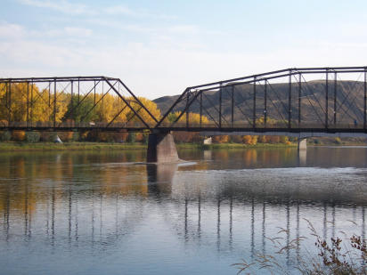
important port on the Missouri River. Fur traders,
gold seekers, and settlers came via steamboats to Fort
Benton, the "Head of Navigation" on the Missouri River.
Today, Fort Benton still retains much of its "steamboat days"
character. Fort Benton, Big Sandy & Geraldine are the
population centers with smaller communities in Loma, Carter,
Floweree, Highwood, Shonkin, and Square Butte.
Chouteau County was once the largest county in the
Montana Territory and the second largest in the United
States. Chouteau County was subdivided repeatedly to
form other counties until it reached its present size, an
area of 3,936 square miles and a population of 5,738.
It is home to the Chippewa-Cree tribe on the Rocky
Boys Indian reservation in the Bear's Paw Mountains to
the northeast, and contains part of the Lewis and Clark
National Forest in the Highwood Mountains to the
south. The terrain is primarily gently rolling plains that
are dissected in the central portion by the eastward
flowing Missouri River. The land is a complex of
uplands, valleys, coulees, and broad plains. The
primary surface water sources are the Missouri, Marias,
and Teton Rivers. Streams of secondary importance
are Highwood, Shonkin, Big Sandy and Arrow Creek.
Contact Information:
Phone numbers for the various departments can be
found on the Departments Page.
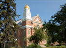
Chouteau County Courthouse
1308 Franklin Street
Fort Benton, Montana


Chouteau County is located in North Central Montana, about
100 miles south of the Canadian border. Established in 1865,
it is one of the original nine counties of the Montana Territory.
It was named in 1882 for Augusta & Pierre Chouteau,
fur traders and owners of the original trading post Historic
Old Fort Benton, from which the community of Fort Benton,
today's county seat, took its name. Fort Benton, named
for Senator Thomas H. Benton of Missouri, was once an
important port on the Missouri River. Fur traders,
gold seekers, and settlers came via steamboats to Fort
Benton, the "Head of Navigation" on the Missouri River.
Today, Fort Benton still retains much of its "steamboat days"
character. Fort Benton, Big Sandy & Geraldine are the
population centers with smaller communities in Loma, Carter,
Floweree, Highwood, Shonkin, and Square Butte.
Chouteau County was once the largest county in the
Montana Territory and the second largest in the United
States. Chouteau County was subdivided repeatedly to
form other counties until it reached its present size, an
area of 3,936 square miles and a population of 5,738.
It is home to the Chippewa-Cree tribe on the Rocky
Boys Indian reservation in the Bear's Paw Mountains to
the northeast, and contains part of the Lewis and Clark
National Forest in the Highwood Mountains to the
south. The terrain is primarily gently rolling plains that
are dissected in the central portion by the eastward
flowing Missouri River. The land is a complex of
uplands, valleys, coulees, and broad plains. The
primary surface water sources are the Missouri, Marias,
and Teton Rivers. Streams of secondary importance
are Highwood, Shonkin, Big Sandy and Arrow Creek.
Contact Information:
Phone numbers for the various departments can be
found on the Departments Page.
Chouteau County, Montana

Chouteau County Courthouse
1308 Franklin Street
Fort Benton, Montana